The geology of Western and Central New York tells an incredible story, the words of which, are laid out in the rolling hills, picturesque valleys, and the seemingly banal roadside cuts throughout this region. The stunningly beautiful cascading waterfalls of Watkins Glen and Ithaca along with the equally dramatic rock city formations of Cattauraugus and Chautauqua Counties round out this tale with a worthy exclamation point.

The nascent bedrock of this region was laid down over 380 million years ago (mya) on what was then an equatorial continent rotated about 45o clockwise from its current orientation (see Figure 1). The fossil remains and geological features also indicate that this area was submersed under a vast shallow ocean (see Figure 2 below).

A continental collision with Baltica (proto Europe) starting 410 million years ago (mya) pushed up the Acadian Mountains that once stood mightily along North America’s east coast. Forces of nature then slowly eroded these huge mountains and the fine particulates flowed deep out onto the Catskill Delta that then covered much of the Southern Tier of New York State, Pennsylvania, Ohio, West Virginia, and eastern Kentucky (Figure 3).

Over vast periods of time those particulates settled to the bottom of the ocean creating layer upon layer of sediment that eventually lithified: the clay sediments became the shale, the silt became siltstone, and the sand became sandstone (see Figure 4).


Standing in this region 380 mya would have necessitated a boat. There were no rolling hills of green – just rolling waves of salty water.
It was likely quite hot (average temp 80° F) with no appreciable winter and certainly no snow. At the bottom of the ocean lived brachiopods, crinoids, coral, placoderm fish, eurypterids, and trilobites. No mammals yet, not even dinosaurs.
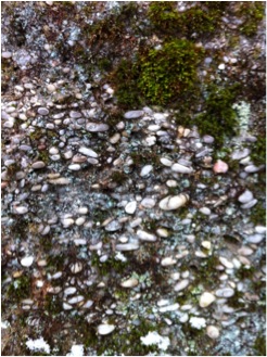
As the mountain sediment inflow slowly filled our sea and worldwide oceanic water levels trended downward, this area slowly approached the shoreline of that shrinking ocean. Today’s sandstone remains are evidence of beachfront long ago. The Acadians continued to shed contents but, larger material was laid down. The top surface of the current mountain top rock city formations of Cattauraugus and Chautauqua Counties were once the bottom of a shallow sea (see Image 1). The pebbles (see Image 2) in those mighty rock city quartz conglomerate rocks were flushed into this shallow sea by torrential floods.

It’s hard to imagine their former lowland status today when standing upon these high points gazing down below at the rolling hills and whittled valleys.
Over yet another immensely vast period of time, the earth remained tectonically active and another continental collision, this time with Africa, pushed up the Allegheny Mountains between 360 and 245 mya. Pangaea, the last super-continent, existed 330 to 220 mya and the dinosaurs reigned supreme on land. About 190 mya the Atlantic Ocean opened and began it’s ongoing expanse. Concurrently our continent was propelled north-by-north-west by plate tectonics, slowly bringing it closer to its current northern hemisphere location. During this gradual transition, a mighty asteroid struck near the Yucatan Peninsula (65 mya) causing a cataclysmic global disaster that is believed to have wiped out the dinosaurs (except for those that evolved into our current birds). Small rodent like mammals did survive and thereafter thrived – ultimately giving rise to us and our fellow mammals.
Until about 1.8 mya the geology of this region remained relatively stable. Things again got exciting as the most recent ice-age commenced. Huge and powerful glaciers slowly carved their way through our landscape gouging out deep valleys and Finger Lake crevasses (see Image 3). They slowly plowed through those long accumulated and lithified deposits creating new lower grounds and thus substantial opportunities for erosion. The surviving rock city formations constitute the few locations in NY that were not scoured by those powerful glaciers. Regardless, the near misses that exposed the under layers of more delicate sedimentary rock beds (e.g., shale), led to the erosion of this base material and thus the characteristic breakage and shifting of those conglomerate structures that make them city like today.

The deep Finger Lake gouges left by the glaciers also left hanging-falls that slowly eroded to form the incredible formations at Watkins Glen, NY (see Image 4), Buttermilk Falls, and Taughannock Falls (in Ithaca, NY).

About that same time, the high peaks of the Adirondacks were just beginning to rise from the north country plains being uplifted by a magma hotspot. The Adirondacks are actually composed of bedrock much older than the bedrock exposed in Central and Western New York.
All of these remnant features are unique and incredibly beautiful landmarks that speak volumes about the vast amounts of time and power that played out in this story. Whenever you pass a roadside cut, think back to when each layer was once the floor of a warm ocean. Make time to get to Rock City in Olean, Panama Rocks in Panama, NY or Thunder Rocks in Allegany State Park. Think about how the top of those rocks, the relative top of the world in Western New York now, were once the bottom of this world. Then picture mountainous walls of snow and ice halting just in time to spare your ground. Finally, imagine their sculpting retreat. What a beautiful and powerful story our wondrous land tells.
References:
Allman, W., & Ross, R. (2008). Ithaca is Gorges: A Guide to the Geology of the Ithaca Area. 4th Ed. Ithaca: Museum of the Earth.
Ansley, J. (2000). The Teacher Friendly Guide to the Geology of the Northeastern U.S. Ithaca: Paleontological Research Institute.
Van Diver, B. (1985). Roadside Geology of New York. Missoula: Mountain Press Publishing Company.
Whiteley, T., Kloc, G., & Brett, C. (2002). Trilobites of New York: An Illustrated Guide. Ithaca: Cornell University Press.
Figures 1-4: John Wiley and Sons – used with permission. http://higheredbcs.wiley.com/legacy/college/levin/0471697435/chap_tut/chaps/chapter11-03.html
Images 1, 2, & 4: Photographs by Gerald Guild
Image 3: NASA Image: http://rst.gsfc.nasa.gov/Sect6/Sect6_2.html

I took a geology class a few years ago and I haven’t looked at the landscape around me the same since.
Pingback:2011- A Year in Review: How Do You Think? – How Do You Think?
Pingback:Irrational Fear: It’s Just an Alief – How Do You Think?